— PALAU · SEPTEMBER–NOVEMBER 1944 —
The Battle of Peleliu
Seventy-three days of cave warfare, coral cliffs, and one of the most controversial operations of the Pacific War. Today, the jungle of Peleliu still holds what the battle left behind — and what was never meant to be forgotten.
KEY FACTS
LOCATION
Peleliu Island, Palau (7.0094°N, 134.2436°E)
OPERATION
Stalemate II
DATES
September 15 – November 27, 1944 (73 days)
US FORCES
1st Marine Division + 81st Infantry Division
JP FORCES
14th Division
US CASUALTIES
~1,794 KIA · ~8,010 WIA
JP CASUALTIES
~10,695 KIA · 202 captured
OUTCOME
Disputed — historians still debate operational necessity
CLUSTER SITES
Peleliu · Ngesebus · Angaur · Babeldaob
Why Peleliu? The Island That May Not Have Needed to Be Taken
By September 1944, the Pacific War had shifted decisively in America’s favor. The Marianas had fallen. B-29 bombers were within striking range of Tokyo from Saipan and Tinian. General Douglas MacArthur was preparing his long-promised return to the Philippines. In the midst of this advance, a small coral island in the western Carolines — roughly seven square miles of limestone, jungle, and coral ridge — was selected for one of the most brutal engagements of the entire war.
Peleliu sat directly on MacArthur’s northern flank as U.S. forces prepared to invade Leyte. The Japanese had spent years transforming the island into a fortress: airfields, underground defenses, and a garrison of over 10,000 men from the experienced 14th Infantry Division. American planners argued that neutralizing Peleliu’s airfield was essential to protecting the Philippine operation.
They were wrong — and some of them knew it.
Admiral William “Bull” Halsey recommended canceling the operation outright, arguing that Peleliu’s garrison was already isolated and that the island posed no real threat. By the time his cable reached fleet command, the invasion was already in motion. It was too late to stop.
The decision to proceed anyway cost nearly 1,800 American lives over the next ten weeks. Today, historians remain divided on whether the Battle of Peleliu was a necessary operation or one of the costliest strategic errors of the Pacific War.
Seventy-Three Days: The Course of the Battle
The Landing — September 15, 1944
At 0830 on September 15, the 1st Marine Division stormed ashore on Peleliu’s western beaches. The landing plan called for a three-regiment front: the 1st Marines on the left near the Umurbrogol highlands, the 5th Marines in the center targeting the airfield, and the 7th Marines on the right.
Japanese commander Colonel Kunio Nakagawa had studied the failures of the earlier banzai-charge doctrine. At Peleliu, his garrison would not contest the beaches directly. Instead, they would let the Marines land, then engage them from fortified positions inland — a strategy that would become standard Japanese doctrine for the remainder of the war.
Within hours, the 1st Marines were taking devastating fire from the Umurbrogol ridges to the north. The 5th Marines, pushing inland across the airfield, lost men to mortar and artillery fire from high ground they could not yet reach. By nightfall, the division had secured a beachhead — but at a cost that foreshadowed the ten weeks of attrition to come.
The Airfield — September 16–18
The capture of Peleliu’s airfield was the nominal objective of the entire operation. By September 18, American forces had secured it, and Marine aircraft were operating from the strip within days — a remarkable logistical achievement even under continuous enemy artillery fire from the surrounding ridges.
But the airfield, once captured, proved far less valuable than planners had anticipated. The Philippine campaign would advance without its direct support, and the strategic justification for Peleliu began to unravel almost from the moment its primary objective was in American hands.
The Northern Advance — September 19–23
With the airfield secured, attention turned to the north of the island, where the Japanese had built their primary defensive positions into the Umurbrogol massif. By September 23, elements of the 5th Marines had reached the northern coast, effectively cutting off Peleliu’s Japanese defenders.
Cutting them off, however, did not mean defeating them. The hardest fighting — and the reason Peleliu would become infamous — was still ahead.

The Umurbrogol: “Bloody Nose Ridge”
Rising from the flat southern plain of Peleliu, the Umurbrogol Pocket was not the mountain that American intelligence had described. Pre-invasion briefings depicted a modest elevation covered in standard jungle vegetation. What the Marines actually found was a jagged, near-vertical coral massif — rising between 50 and 300 feet — riddled with natural caves, sinkholes, and karst formations that the Japanese had spent two years reinforcing into an underground fortress.
The Marines named it Bloody Nose Ridge. They had reason to.
Over the following six weeks, American forces fought for every ridgeline, every coral outcrop, every cave entrance. The Japanese had constructed an interconnected defensive system of more than 500 natural and artificial caves, linked by tunnels, equipped with sliding steel doors, and positioned with interlocking fields of fire. An attack on one position drew fire from three others.
The 1st Marines lost 71 percent casualties in a single week of fighting for the ridge. The 5th and 7th Marines lost roughly half their men. When the division was finally withdrawn in mid-October, its combat effectiveness was so reduced that the U.S. Army’s 81st Infantry Division had to complete the operation.
Colonel Nakagawa committed suicide in his command cave on November 24, 1944. The final organized Japanese resistance on Peleliu ended three days later.
“The fight for Peleliu was one of the most vicious and stubbornly defended battles of the war.”
— General Clifton Cates, later Commandant of the Marine Corps
The Cave System: Japan’s Underground Fortress
To understand Peleliu is to understand its caves. Nothing in American pre-war planning, and nothing encountered in the previous battles of Tarawa, Saipan, or the Solomons, prepared Marines for what lay beneath the Umurbrogol.
The Japanese defensive system on Peleliu was built around three principles: depth, concealment, and mutual support. Rather than fortifying a single defensive line, Nakagawa’s engineers had transformed the entire massif into a single integrated complex. Caves held fighting positions, living quarters, command posts, hospitals, ammunition storage, and water supplies. Many could only be entered through angled passages designed to deflect grenades and flamethrower fire.
The most infamous of these is the 1,000-Man Cave — a 284-meter tunnel system containing 34 rooms, including a hospital and a shrine. When American forces finally reduced it, they did so by sealing the exits with explosives and using flamethrowers against the interior. Today, the cave still bears the scorch marks of that final assault.
Other caves across the island housed much smaller garrisons — sometimes a single squad, sometimes a single soldier. It was not uncommon, in the years immediately following the war, for stranded Japanese holdouts to emerge from Peleliu’s cave system believing the war had not ended. The last confirmed holdouts surrendered in 1947.
Peleliu Today: A Battlefield Preserved by Time
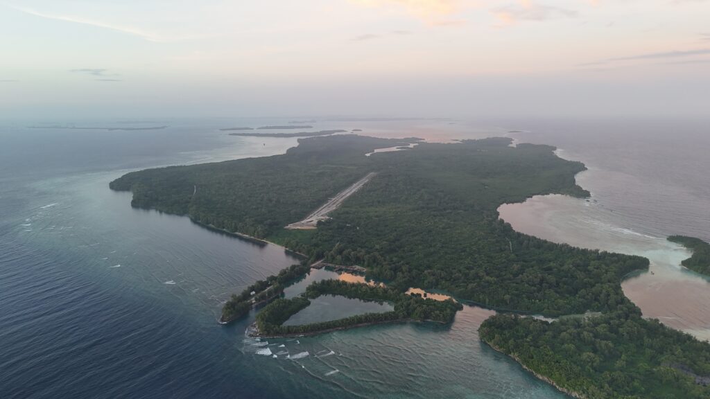
Peleliu in the twenty-first century is one of the most remarkable preserved battlefields on Earth. The island’s population today numbers roughly 700 people, concentrated in the village of Klouklubed. There is no resort development. There are few roads. There is no commercial archaeological extraction. The battle remains where it ended.
This preservation is not accidental. The Republic of Palau has implemented some of the strictest cultural and environmental protections in the Pacific, and the removal of military artifacts is prohibited by law. Sites across the island remain under active demining operations — over 4,800 unexploded ordnance items have been cleared along the marked path to Colonel Nakagawa’s command cave alone.
The result is a landscape that looks, in many areas, as it did in 1944. Sherman tanks rest where they were disabled. A Japanese Type 95 Ha-Go tank sits overturned near the airfield road, its hull punctured by American fire. Along Orange Beach and White Beach, the coral still holds traces of the amphibious landings. Artillery positions on the Umurbrogol ridges remain in place, their barrels pointing toward beaches where the Marines first came ashore.
For collectors, historians, and families of veterans, Peleliu offers something no museum can: the battle in situ. Nothing has been curated. Nothing has been rearranged. What you see is what eighty years of tropical weather, jungle growth, and local stewardship have allowed to remain.
Relics of Peleliu: What You’ll Find in the Jungle
Walking Peleliu with a trained eye reveals layer after layer of 1944. The island’s coral substrate protects ferrous metal remarkably well, and its tropical climate — while harsh on canvas, wood, and leather — has left a dense archaeological record of the battle.
American Artifacts
The most commonly encountered American artifacts on Peleliu are .30-06 Springfield cartridge casings — the standard ammunition for the M1 Garand, M1903 Springfield, and M1919 Browning machine gun. Headstamps typically bear “FA” (Frankford Arsenal), “LC” (Lake City), or “DEN” (Denver Ordnance Plant), along with a two-digit year marker. Casings dated 43 or 44 are most common on Peleliu and represent ammunition manufactured specifically for the Pacific campaign.
Larger American artifacts include the remains of LVT amphibious tractors along the landing beaches, Sherman tank hulls disabled during the advance inland, and scattered components of field artillery — primarily the 75mm pack howitzers and 105mm M2 howitzers that supported the ground advance.
Japanese Artifacts
Japanese material dominates the cave systems and ridge positions. The most common finds are:
- Type 38 Arisaka 6.5×50mm cartridges, the older rifle round still in widespread use among garrison units
- Type 99 Arisaka 7.7×58mm cartridges, the standard-issue round for front-line infantry by 1944
- Type 92 machine gun components, particularly the distinctive hopper-fed heavy machine guns used in defensive positions
- Remnants of the Type 95 Ha-Go tank and Type 97 Chi-Ha tanks, several of which remain visible on the island today
- Artillery pieces, including the Type 88 75mm anti-aircraft guns repurposed for coastal defense
Personal items are rarer but still surface occasionally: mess kit fragments, sake bottles, helmet shells, and bayonets. The 1,000-Man Cave famously contained personal effects for decades after the battle, though the majority of removable items have since been curated into the Peleliu WWII Memorial Museum.
The Coral Record
What makes Peleliu unique among Pacific battlefields is the coral substrate itself. Unlike the volcanic soils of Saipan or Guadalcanal, Peleliu’s limestone preserves archaeological context with remarkable clarity. Shell craters from pre-invasion naval bombardment remain visible eight decades later. Ridgelines carry the scars of individual engagements. In several locations, the pattern of spent brass on the ground still reflects the firing arcs of 1944.
For those who know how to read it, Peleliu is not just a battlefield. It is an open-air archive.
Visiting Peleliu: Ethics, Law, and Respect
Peleliu is open to visitors. It is not open to collectors.
The Republic of Palau’s legal framework, combined with active U.S. and Japanese cultural protections, prohibits the removal of military artifacts from any of the Palau islands. Violations carry significant penalties, and enforcement has increased steadily as the island’s strategic heritage has gained international recognition.
More importantly, Peleliu remains sacred ground — for the American families whose fathers and grandfathers fought there, for the Japanese families whose ancestors died there, and for the Palauan communities whose homeland hosted one of the twentieth century’s most brutal battles. Every artifact that remains in place is part of that memorial.
The approach I’ve taken across years of exploration — and the approach I would ask any fellow visitor to take — is documentation over extraction:
- Photograph in situ
- Record coordinates
- Share what you find
- Leave it where the battle left it
Peleliu has survived eighty years because the people who come here have understood that some landscapes are more valuable intact than disturbed. The battle was fought so that this island could exist as it does today. The least we can do, as the generations that follow, is honor that by walking lightly.
Frequently Asked Questions
Where exactly is Peleliu located?
Peleliu is a small island in the Republic of Palau, in the western Pacific Ocean. Its coordinates are 7.0094°N, 134.2436°E. The island is approximately 13 km² in area and sits in the southern Palau archipelago.
Why was the Battle of Peleliu controversial?
Admiral William “Bull” Halsey recommended canceling the operation entirely, arguing that Peleliu’s Japanese garrison was already isolated and posed no real threat to the Philippine campaign. By the time his cable reached fleet command, the invasion was already underway. The decision to proceed cost nearly 1,800 American lives over 73 days, and historians still debate whether the operation was strategically necessary.
What is the 1,000-Man Cave on Peleliu?
The 1,000-Man Cave is a 284-meter underground tunnel system on Peleliu containing 34 rooms — including a hospital and a shrine. It was one of the largest fortified caves used by Japanese defenders during the battle. American forces ultimately reduced it by sealing the exits with explosives and using flamethrowers. Today, the cave still bears the scorch marks of that final assault.
Can I visit Peleliu battlefield sites today?
Yes. Peleliu is open to visitors and is one of the most preserved WWII battlefields on Earth. However, the removal of military artifacts is prohibited by Republic of Palau law. Visitors must respect strict cultural and environmental protections. Local guides are recommended due to remaining unexploded ordnance — over 4,800 UXO items have been cleared along the marked path to Colonel Nakagawa’s command cave alone.
What kinds of WWII relics can be found on Peleliu?
American artifacts include .30-06 Springfield casings (M1 Garand, M1903, M1919 Browning), components of Sherman tanks and LVT amphibious tractors, and 75mm/105mm howitzer remains. Japanese artifacts dominate the cave systems: Type 38 (6.5×50mm) and Type 99 (7.7×58mm) Arisaka cartridges, Type 92 machine gun parts, Type 95 Ha-Go and Type 97 Chi-Ha tank remains, and Type 88 75mm AA guns repurposed for coastal defense.
When did the Battle of Peleliu end?
Organized Japanese resistance officially ended on November 27, 1944 — three days after Colonel Nakagawa’s suicide on November 24. However, isolated Japanese holdouts continued to emerge from Peleliu’s cave system for years after the war. The last confirmed holdouts surrendered in 1947, almost three years after the battle’s official end.
The Palau Expedition Map
Every site I’ve documented across Peleliu, Ngesebus, Angaur, and Babeldaob — with photos, coordinates, and the story behind each find.